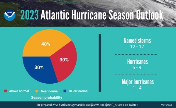
BALTIMORE, MD—NOAA forecasters with the Climate Prediction Center, a division of the National Weather Service, predict near-normal hurricane activity in the Atlantic this year. NOAA’s outlook for the 2023 Atlantic hurricane season, which goes from June 1 to November 30, predicts a 40% chance of a near-normal season, a 30% chance of an above-normal season and a 30% chance of a below-normal season.
NOAA is forecasting a range of 12 to 17 total named storms (winds of 39 mph or higher). Of those, 5 to 9 could become hurricanes (winds of 74 mph or higher), including 1 to 4 major hurricanes (category 3, 4 or 5; with winds of 111 mph or higher). NOAA has a 70% confidence in these ranges.
“Thanks to the Commerce Department and NOAA’s critical investments this year in scientific and technological advancements in hurricane modeling, NOAA will be able to deliver even more accurate forecasts, helping ensure communities have the information they need to prepare for and respond to the destructive economic and ecological impacts of Atlantic hurricanes,” said Secretary of Commerce Gina M. Raimondo.
The upcoming Atlantic hurricane season is expected to be less active than recent years, due to competing factors — some that suppress storm development and some that fuel it — driving this year’s overall forecast for a near-normal season.

After three hurricane seasons with La Nina present, NOAA scientists predict a high potential for El Nino to develop this summer, which can suppress Atlantic hurricane activity. El Nino’s potential influence on storm development could be offset by favorable conditions local to the tropical Atlantic Basin. Those conditions include the potential for an above-normal west African monsoon, which produces African easterly waves and seeds some of the stronger and longer-lived Atlantic storms, and warmer-than-normal sea surface temperatures in the tropical Atlantic Ocean and Caribbean Sea which creates more energy to fuel storm development. These factors are part of the longer term variability in Atlantic atmospheric and oceanic conditions that are conducive to hurricane development — known as the high-activity era for Atlantic hurricanes — which have been producing more active Atlantic hurricane seasons since 1995.
“With a changing climate, the data and expertise NOAA provides to emergency managers and partners to support decision-making before, during and after a hurricane has never been more crucial,” said NOAA Administrator Rick Spinrad, Ph.D. “To that end, this year we are operationalizing a new hurricane forecast model and extending the tropical cyclone outlook graphic from five to seven days, which will provide emergency managers and communities with more time to prepare for storms.”
“As we saw with Hurricane Ian, it only takes one hurricane to cause widespread devastation and upend lives. So regardless of the number of storms predicted this season, it is critical that everyone understand their risk and heed the warnings of state and local officials. Whether you live on the coast or further inland, hurricanes can cause serious impacts to everybody in their path,” said FEMA Administrator Deanne Criswell. “Visit https://www.ready.gov or https://www.listo.gov for readiness resources, and get real time emergency alerts by downloading the FEMA App. Actions taken today can save your life when disaster strikes. The time to prepare is now.”

NOAA’s outlook is for overall seasonal activity and is not a landfall forecast. In addition to the Atlantic seasonal outlook, NOAA also issues seasonal hurricane outlooks for the eastern Pacific and central Pacific hurricane basins. NOAA’s Climate Prediction Center will update the 2023 Atlantic seasonal outlook in early August, just prior to the historical peak of the season.
The official start of the Atlantic hurricane season is June 1 and runs through November 30.
Do you value local journalism? Support NottinghamMD.com today.

